The Sixth Station of the Exodus is called Elim. In Numbers 33:9-11 we read:
And they removed from Marah, and came unto Elim: and in Elim were twelve fountains of water, and threescore and ten palm trees; and they pitched there. And they removed from Elim, and encamped by the Red sea. And they removed from the Red sea, and encamped in the wilderness of Sin. (Numbers 33:8-9)
This suggests that Elim was no more than a day’s march from Marah and a day’s march from the Red Sea, in the vicinity of the Wilderness of Sin. Before Marah, the Israelites were in the Wilderness of Shur or Etham, which we have identified with the desert region of northern Sinai, between the Mediterranean coast and the Tih Plateau.
Note also that in the King James Version, Red sea translates the Hebrew phrase סֽוּף יַם־ [yam-sūp̄], or Yam Suph, which we identified in an earlier article with Lake Ballah:
The commonest interpretation is that suph is a Hebrew word for rush, reed, bulrush, seaweed (Gesenius 1835:943). It is thought that the word was adapted from the Egyptian word ṭwfi, meaning reeds (Brown 693). The implication is that the sea in question was one of the brackish lakes of the eastern Delta: Lake Ballah, Lake Timsah, or the Great Bitter Lake. (The latter, however, probably did not exist at the time of the Exodus, as the northern shoreline of the Red Sea proper lay much further north than it does today.) Brown & Robinson, according to their 1906 edition of Gesenius, believe that the traditional reference to the Red Sea is sound.
It is, therefore, possible that yam suph simply means a sea of reeds rather that The Sea of Reeds. In other words, it may not necessarily refer to the same sea as before. If, however, the phrase refers to the same sea as before, then it is hard to square this with the conclusion we drew in the previous article: Marah probably lay somewhere to the east of the modern city of Suez.
In the Book of Exodus, the account of this episode is curiously different from that found in Numbers:
And they came to Elim, where were twelve wells of water, and threescore and ten palm trees: and they encamped there by the waters. And they took their journey from Elim, and all the congregation of the children of Israel came unto the wilderness of Sin, which is between Elim and Sinai, on the fifteenth day of the second month after their departing out of the land of Egypt. (Exodus 15:27–16:01)
Note that the Seventh Station of the Exodus, the Red Sea, is missing. Instead, the Israelites pass directly to the Eighth Station, the Wilderness of Sin. Is it possible that the seventh station is spurious and should be removed from the list? This would certainly eliminate the problem of squaring our identification of Yam Suph with Lake Ballah with our identification of Marah with one of the springs near Suez.
Note also that we are told specifically that the Israelites reached the eighth station, the Wilderness of Sin, on the fifteenth day of the second month since leaving Egypt. In the light of Numbers 33:03, this is generally understood to mean one lunar month (29-30 days) after they set out on the Exodus from Rameses (Avaris):
And they departed from Rameses in the first month, on the fifteenth day of the first month; on the morrow after the passover the children of Israel went out with an high hand in the sight of all the Egyptians. (Numbers 33:03)
If we accept that successive stations were separated by a day’s march—except for Pi-Hahiroth and Marah, which we are told were separated by a three days’ march—then we must conclude that the Israelites rested at some of the stations for several days at a time.
Elim
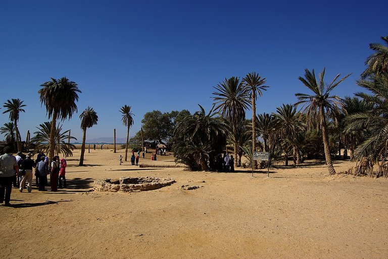
In the preceding article, we tentatively identified the fifth station, Marah, with one of the desert springs in the vicinity of the modern city of Suez—the most likely candidate being Bîr el Murra, which is situated about 15 km east of Suez. This immediately suggests that Elim is to be identified with ‘Ayun Musa, or the Wells of Moses, an oasis about 15 km southeast of Suez or 12 km southwest of Bîr el Murra. In _The Jewish Study Bible, Jeffrey H Tigay comments:
27: Elim, possibly Wadi Gharandel, the best-watered site in western Sinai, about 15 km (9 mi) south of Ein Hawarah, or Uyun Musa, 12 km (7.5 mi) southwest of Bir el-Murrah, which has a palm grove and twelve springs even today. (Berlin & Brettler 139)
Wadi Gharandel is about 90 km south of ‘Ayun Mûsa , which is too far from Bîr el Murra to be reached in a day’s march. On the other hand, ‘Ayun Mûsa is only 15 km from Bîr el Murra, which James K Hoffmeier thinks is too short a distance for the Israelites to have pitched camp at both locations. In the previous article, however, I suggested that if the Israelites, running short of water after three days in the desert, pitched camp at Marah only to find that the water was bitter, they may very well have pitched camp at nearby ‘Ayun Mûsa if the water there was potable. The miracle of Moses making the bitter waters of Marah sweet by casting a branch into it may very well be a spurious and later embellishment of the original account.
In short, I have no problem with identifying Marah with Bîr el Murra and Elim with ‘Ayun Mûsa, even if they are only 15 km from each other.
‘Ayun Mûsa
In Exodus, we are told very explicitly that Elim had twelve fountains of water, and threescore and ten palm trees. As we have just seen above, ‘Ayun Mûsa allegedly has a palm grove and twelve springs to this very day. Could this be a mere coincidence?
Unfortunately, this “fact” is disputed. According to Hoffmeier:
When Robinson visited the site in 1838, he counted seven springs. (Hoffmeier 162)
Edward Robinson’s account does not inspire confidence that this could be Elim:
We reached ’Ayun Mûsa half an hour afterwards. Here I counted seven fountains, several of them mere recent excavations in the sand, in which a little brackish water was standing. Others were older and more abundant; but the water is dark-coloured and brackish ... The Arabs call the northernmost spring sweet; but we could not perceive that it differed much from the others ... About twenty stunted untrimmed palm trees, or rather palm bushes, grow round about in the arid sand. (Robinson 62)
And in Volume 2 of Heinrich Ewald’s History of the People of Israel, the number of springs at ‘Ayun Mûsa is given as forty! (Ewald 99: fn 1)
Of course, it may have been quite different two millennia ago. The mere fact that ‘Ayun Mûsa has a name that means Wells of Moses is surely significant. The place is mentioned twice in the Quran, though the text appears to conflate Elim and its twelve springs with the eleventh station, Rephidim, where Moses strikes a rock with his staff to produce water:
And when Moses prayed for water for his people, We said: March on to the rock with thy staff. So there flowed from it twelve springs. Each tribe knew their drinking-place. Eat and drink of the provisions of God, and act not corruptly, making mischief in the land. (Quran 2:60)
And We divided them into twelve tribes, as nations. And We revealed to Moses when his people asked him for water: Strike the rock with thy staff; so out flowed from it twelve springs. Each tribe knew its drinking-place. And We made the clouds to give shade over them and We sent to them manna and quails. Eat of the good things We have given you. And they did not do Us any harm, but they wronged themselves. (Quran 7:160)
But these references do not identify the location, so we cannot conclude from them that ‘Ayun Mûsa was already associated with Moses in the 7th century, when the Quran was composed.
Other Candidates
Several other oases and springs in western Sinai have been suggested as candidates for Elim. They are briefly discussed by the German theologian August Dillmann in his commentary on the Book of Exodus (Dillmann 179-180). Some of these have also been suggested as candidates for the preceding station, Marah, so we have already met them:
- ‘Ain Nâba, or el Gharqada, 4 km north of ‘Ayun Mûsa
- Wâdi el ‘Amâra, 70 km south of ‘Ayun Mûsa
- ‘Ain Ḥawârah, 80 km south of ‘Ayun Mûsa
- Wâdi Gharandel, 90 km south of ‘Ayun Mûsa
- Wâdi Usait, 97 km south of ‘Ayun Mûsa
- Wâdi Ṭaijibe [Wadi Taiyibeh], 100 km south of ‘Ayun Mûsa
- Abu Zelîme [Abu Zenima], a headland at the mouth of the Wadi Ṭaijibe.
The last six are too far from Bîr el Murra to have been reached in one day (or too far from Lake Ballah to have been reached in four days). ‘Ain Nâba, or el Gharqada is a viable candidate, but Dillmann describes it as having an extremely abundant spring with very salty water (Dillmann 178). All in all, ‘Ayun Mûsa seems to be the better candidate.
The Name Elim
Why is this station called Elim? This is a mystery that has never been solved.
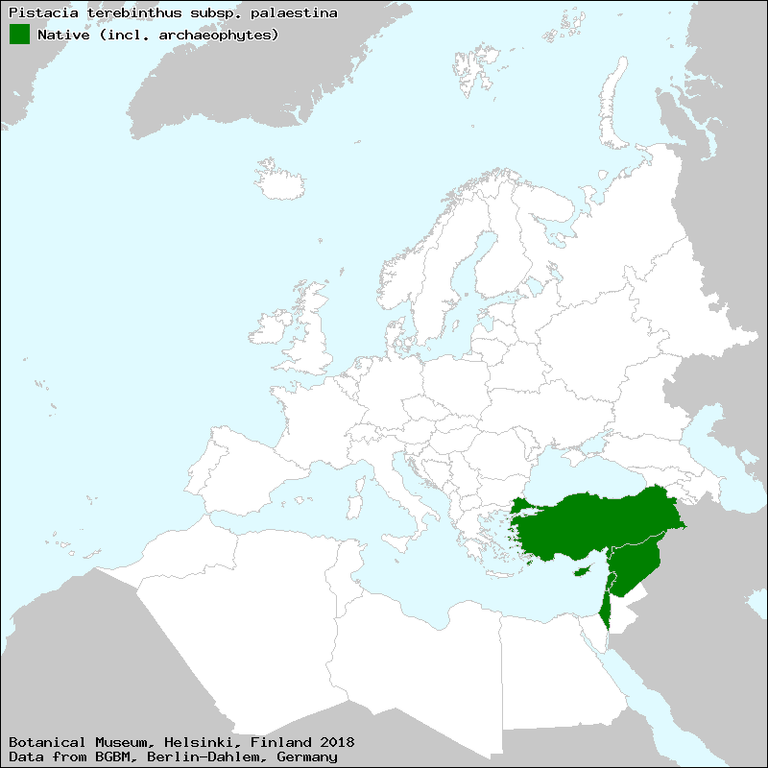
Attempts have been made to link the name with that of Elath or Eloth, a city in Edom at the head of the Gulf of Aqaba. Elath is believed to signify lofty trees or grove of lofty trees. In English translations of the Old Testament, the Hebrew word אלה [’alla] is usually rendered as either oak or terebinth](https://en.wikipedia.org/wiki/Pistacia_palaestina). The terebinth is mentioned several times in the Scriptures, though never during the Exodus. It is common throughout the Levant, but it is not associated with Sinai.
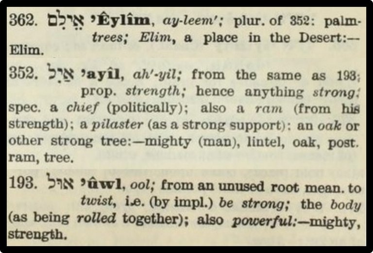
In his Hebrew and Chaldee Dictionary, James Strong makes Elim the plural of a word that literally means strength—hence anything strong. In this context, he defines it as an oak or other strong tree. He traces it back to a root that means: to twist, i.e. (by implication) to be strong ... also powerful (Strong 11, 9):
Conclusion
After leaving Elim, the Israelites entered the Wilderness of Sin. The identity of this station will obviously have some bearing on the identity of Elim. In the meantime, I will tentatively identify Elim with ‘Ayun Mûsa.

To be continued ...
References
- Adele Berlin & Marc Zvi Brettler (editors), _The Jewish Study Bible , Jewish Publication Society TANAKH Translation, Oxford University Press, Oxford (1999)
- Francis Brown, Edward Robinson, William Gesenius, A Hebrew and English Lexicon of the Old Testament, Clarendon Press, Oxford (1906)
- Heinrich Ewald, The History of Israel, Translated from the German, Second Edition, Volume 2, Longmans, Green & Co, London (1869)
- Wilhelm Gesenius, Philological and Critical Thesaurus of the Hebrew and Chaldee Languages of the Old Testament, Volume 1, F C G Vogel, Leipzig (1835)
- James K Hoffmeier, Ancient Israel in Sinai: The Evidence for the Authenticity of the Wilderness Tradition, Oxford University Press, Oxford (2005)
- Edward Robinson, Biblical Researches in Palestine and in the Adjacent Regions Volume 1, Crocker & Brewster, Boston (1856)
- Isidore Singer (managing editor), The Jewish Encyclopedia, Volume 11, Funk & Wagnalls Co, New York (1905)
- James Strong, The Exhaustive Concordance of the Bible, Eaton & Mains, New York (1890)
Image Credits
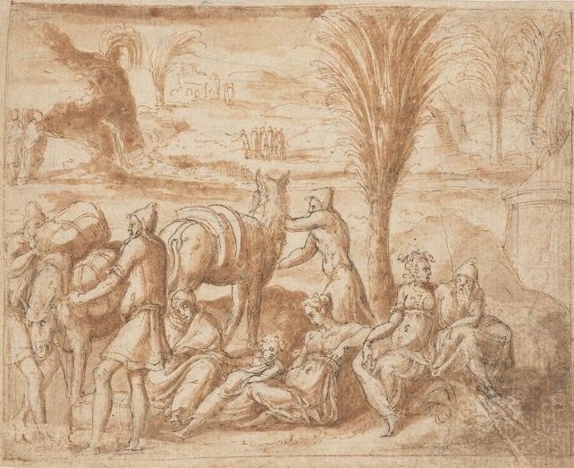
- The Hebrews Camping in Elim (Salomon): Bernard Salomon (artist), TypDr 515.S766.50q (15), Houghton Library, Harvard University, Public Domain
- ‘Ayun Musa: © Berthold Werner, Creative Commons License
- Distribution of the Terebinth (Pistacia palaestina): © Botanical Museum, Helsinki : Data © Botanic Garden and Botanical Museum Berlin-Dahlem 2006 : Published on the Internet by Euro + Med Plantbase [accessed 19 April 2019]
- Marah and Elim?: University of Texas Libraries, Perry-Castañeda Library Map Collection, US Army Map Service (1959), Public Domain

Very good journal writting bro...keep going..we r with you
I can learn something from your post that is very good to me. You do not have any comparison...thank you...
Wow what a beautiful story I like your post thank you for sharing with us.