I captured this video last February 3, 2025. It's Monday and it's my day off from my corporate world. So Instead of staying at home, I decided to go out and practice my skills in controlling my first new drone DJI Flip. And this is what I discover, The Unexpected Scenic View Above Lipa Batangas.
It was already 3:00 pm when I went out of the house, then I went to a bypass road in Lipa Batangas. It is just fifteen minutes away from my house. It is a wide-open area and perfect for practicing my drone as a newbie operator.
Im thrilled to tr the different features of this drone specifically the AI commands. It's fascinating and it's a bit handy for me to drive even though Im just a newbie and relying on some tutorials on DJI Web. Its easy to control and navigate the features. I just fly it short elevation cause Im still afraid to try its maximum altitude.
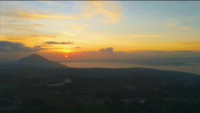
500 meters is the maximum altitude of my drone to reach. At first, I was hesitant to max it but when I saw the screen with this view Im got excited to unfold the scenic view above Lipa Batangas.
From this elevation, you will see the astonishing view of Taal Lake and the Taal Volcano. I was amazed when I saw this I never expected to capture this view from Lipa Batangas. Also, this video highlights the beautiful mountains of Mt. Makiling and Mt. Manabu of Sto. Tomas Batangas. The mountains stand beautifully with green fields covering its all area. In this video also you see the aerial view of the booming City of Lipa. The city is not yet congested but I hope it will not, you will observe a lot of greens are still covering the area of Lipa.
This video simply astonishing, its Highlights the amazing nature that surrounds the Lipa Batangas and the beautiful heu of the sky during the golden time. Im glad I went out that day and captured this amazing view of nature. Im excited to capture more beautiful landscapes above together with this new friend of mine, DJI Flip.
That's it for now, expect for more aerial video soon. Thank you for joining me on this blog and checking out this video.
This is @intoy.bugoy! See you in my next Hiventure 😉
Not so tall, not so dark, not so handsome but surely I'm a CUTE one 😊MyTravelstories). .Your Civil Engineer, Real Estate Agent and Financial Adviser. I'm into Travel's and Photography. Knowing the culture of one place is my interest. Come and join me in discovering this infinite beautiful world following all my #LakwatsaniIntoy diaries (
If hIS content made you 😁, then drop some ❤️ by upvoting and leaving a comment. Also, click the Follow button to keep posted on his journey here on Hiive.
Let's Connect In My: INSTAGRAM | TWITTER | FACEBOOK ▶️ 3Speak
Genuinely surprised the flip managed to reach 500m! Though I just saw it has a weight of 249g like their Mini lineup. I haven't pushed my Mini 2 that high before, I think the highest is about 360m in the middle of nowhere in Armenia. Absolutely zero wind in that environment I flew in. Usually I'd start getting a strong wind warning around 120m back in England even if things were relatively smooth on the ground.
A major bit of advice I'd give for flying high though is take a look online at general flight traffic for planes and helicopters in the area first. See if it's likely that anything might fly in that area throughout the day. The main thing that stops me from flying high is never the wind, but the fear that I might cause an accident that was so stupidly easy to avoid. But when I know it's all clear from researching first, I fly it all over the place ;^)
Your comment is upvoted by @topcomment
Info - Support - Discord
Thank you for a great advise @namiks, I just try to see its max capacity. Actually in our area the advise is only 210. But I'm being naughty to try it but I assure first that my area is all clear for possible accident. After that I never do it again. I'm scared after I realised I do something illegal.
Thank you again for the advice
Yeah I'd really love to do some seriously high flights with my Mini 2. The 360m one I did was without actually realising it was that high, I was searching for something in the landscape and had to fly over a mountain. It was far from any flight paths though so I could've gone higher.
In England I couldn't go that high. Even though I lived in the countryside there were so many planes and helicopters flying daily, and really low too. There even started to be fighter jet exercises over my house in the countryside that'd happen out of nowhere. There was a genuine risk of me causing a serious accident if I wasn't careful enough, but I still flew the drone almost daily, I'd just make sure I didn't go too high.
I'm in Georgia now and had a situation that surprised me, it wasn't even in the flight paths and must've been a private jet that was coming in, flying incredibly low. With cities it's easier to get an idea of height since you know you can fly a bit higher than the skyscrapers, but even around there this plane appeared out of nowhere and my heart sank for a second.
Whenever I do fly I do two things first: Google Maps to ensure no airports or military bases/police stations are nearby. Then check flightradar and historic flight routes to be sure nothing will be around the area remotely close to the altitude I intend.
Still surprised the Flip managed to reach 500m though! Did you get any wind warnings at all? Or was it a really still day that's perfect for flying?
I got some wind warning actually 😅, but it has quickly gone, I was actually that day that theirs no stronger winds than usual in our place so I pushed it to Max level. It was already 5 pm when I capture this video.
I never try yet in the City, but maybe at the time I'm comfortable doing it. I don't know what to do If I will experience what you had in Georgia.
This is helpful. Thank you for this
What a beautiful scenary, the landscape, that mountain in the background and the orange shining sun! 😍 Also the music in the video is very relaxing.
Hi @gen-quimba, Glad you like it po maam @gen-quimba
Truly astonishing. More aerial video soon @intoy.bugoy 🤍
It is @dawnver, Glad you like it, More video soon
!CURATE BY
@biologistbrito
Thank you for your contribution to the community🌍🐏
Remember to delegate to us or join the curation trail to participate in the weekly hbd prizes🥇🏅
Thank you so much @hive-174680 and @biologistbrito for the support.
You can check out this post and your own profile on the map. Be part of the Worldmappin Community and join our Discord Channel to get in touch with other travelers, ask questions or just be updated on our latest features.
Ka nindot sa view Sir,
Lagi maam,nice kaayo siya sa Mata
Nice video. Those first flights above are certainly amazing to see. For all those not into drones yet, that's part of what you're missing!
Be sure to join our community so you're eligible for the weekly contests!
https://peakd.com/c/hive-186141/created
Thank you @ksteem for welcoming me into this great community. Glad you like the video.
Congratulations @intoy.bugoy! You have completed the following achievement on the Hive blockchain And have been rewarded with New badge(s)
Your next target is to reach 3500 replies.
You can view your badges on your board and compare yourself to others in the Ranking
If you no longer want to receive notifications, reply to this comment with the word
STOPCheck out our last posts: