Respetables lectores y estudiantes de las Ciencias Naturales dentro del área de la Geología, en esta oportunidad les presento un informe amenamente sencillo, acerca de los Glaciales, del cual se expone su definición, formación y tipos existentes con sus características, además de sus consecuencias; también se da a conocer las áreas geográficas donde se ubican.
.png)
“…es una gruesa masa de hielo y nieve originada en la superficie terrestre por acumulación, compactación y recristalización de la nieve, mostrando evidencias de flujo en el pasado o en la actualidad. Su existencia es posible cuando la precipitación anual de nieve supera la fusionada en verano, por lo cual la mayoría se encuentra en zonas cercanas a los polos, aunque existen en otras zonas, en montañas. El proceso del crecimiento y establecimiento del glaciar se llama glaciación. Los glaciares del mundo son variados y se pueden clasificar según su forma ya sea de valle, de nicho, campo de hielo o por régimen climático como el tropical, temperado o polar, o condiciones térmicas de base fría, base caliente o politermal…” Glaciar
Un glaciar se encuentra constituido por una masa de hielo acumulado sobre tierra firme con una cierta inclinación, que por esa razón tiene una tendencia al desplazamiento sobre el agua. Este movimiento, característico del glacial, constituye a la vez el instrumento de erosión. La nieve acumulada en altitudes elevadas y frías, se compacta progresivamente, pasando a convertirse en hielo. Cuando éste inicia el movimiento de descenso, va erosionando las rocas, a la vez que transporta una serie de materiales para, finalmente, depositarlos en un punto dado, donde se funde.
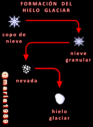
La relación entre la acumulación que se produce y su fusión establece el crecimiento, retroceso o equilibrio de un glaciar. Son varios los tipos existentes, pero los más comunes son:
Glaciar Continental o Inlandsis, los clasificados en este grupo ocupan grandes extensiones de terreno y son permanentes, de forma que cubren totalmente una determinada región; su flujo es radial y su superficie es planoconvexa (que posee una superficie plana y otra convexa). Se recomienda ver Inlandsis de la Antártida.
Glaciares del Valle, poseen un área de acumulación muy localizada, dentro de una depresión denominada circo, desde donde fluyen por una serie de valles que constituyen la lengua del glaciar. También existen glaciares incapaces de superar su circo, por lo que se denominan glaciares de circo.
.jpg)
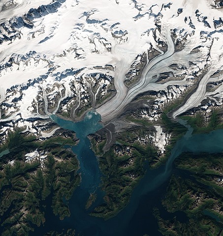
“El glaciar Columbia en Alaska muestra la anomalía de su frente cóncavo, lo que nos indica que el hielo se derrite más rápidamente en su parte central (que es la que mayor volumen y profundidad tiene) por la sencilla razón de que las aguas relativamente cálidas del océano derriten rápidamente dicho frente al llegar al nivel del mar.”
El hielo erosiona los lugares por los que discurre, actuando a modo de gigantesca lima. La acción de los glaciares de lugar a un modelado característico en los valles, los cuales adoptan forman de “U” y se denominan artesas glaciares. Dichos valles presentan, además, una serie de formaciones típicas, como las cubetas de sobre excavación, así como un conjunto de espolones, crestas, etc., que sobresalen y están situados ramal debajo de la cubeta. Cuando el hielo desaparece las cubetas se convierten en lagos. Existen otras formas, aunque menores de erosión, como es el caso de las rocas aborregadas, que poseen sus caras redondeadas y pulidas como consecuencia de la acción del hielo.
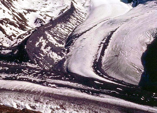
En su zona terminal, el glaciar forma las morrenas, que consisten en acumulaciones de rocas arrastradas por el hielo. Sí se encuentran en los márgenes de las paredes del valle se denominan morrenas laterales, y cuando aparecen en las áreas centrales, se les llaman morrenas centrales o medianas. Igualmente existen materiales “morrénicos” en el lado frontal de la lengua, que reciben el nombre de morrenas frontales o terminales. Cuando un glaciar retrocede o desaparece, subsisten las morrenas; éstas se caracterizan por su falta de estratificación y por su heterometría; la morena frontal tiene forma de arco. Otro tipo de morrena es la de fondo, formada por aquellos materiales que han sido transportados a la zona basal.
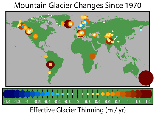
“Este mapa del balance de cambios de los glaciares de montaña desde el año de 1970 muestra la disminución del grosor en amarillo y rojo, y el aumento en azul.”
En las áreas geográficas situadas alrededor de los glaciares, las denominadas Regiones Periglaciares, las mayor parte de las características que presenta el paisaje se encuentran relacionadas con los fenómenos de glaciarismo y de erosión mecánica, debidos a la acción del hielo, así como con los procesos de sedimentación derivados del deshielo, acarreo de materiales, etc. Cuando la presencia del frío se ha prolongado durante mucho tiempo, el suelo se ha helado a varios metros de profundidad, e incluso a unas decenas de metros. Por esta causa la fusión queda limitada al verano, y eso de forma superficial. El agua al no poder penetrar en este suelo, forma en estas áreas periglaciares suelos permanentemente fangosos o helados, que actúan como una capa impermeable que impide toda filtración.
.jpg)
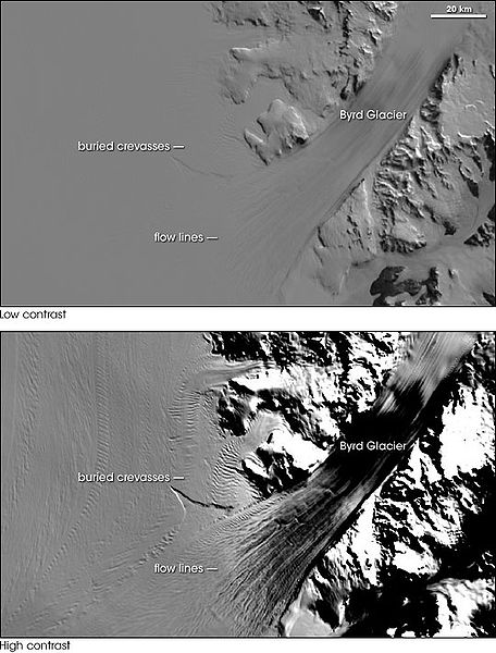
“Fotografías con bajo y alto contraste del Glaciar Byrd (Antártida). La versión de bajo contraste es similar en nivel de detalle a lo que el ojo vería-suave y casi sin rasgos característicos. La fotografía inferior utiliza un contraste aumentado para destacar las líneas de flujo en la capa de hielo y en las grietas inferiores.”

¡ SIEMPRE GRACIAS
POR SU AMABLE ATENCIÓN !
POR SU AMABLE ATENCIÓN !
Buscando siempre la motivación a enriquecer el aprendizaje que fortalecerá el proceso educativo de la humanidad, se utiliza esta red social como herramienta de comunicación para así poder llevar la información a todos los rincones de este mundo globalizado.

Dedico este informe a la formación educativa y cultural de todo aquel que conoce su importancia y respeta lo valioso de la educación integral
❀❀@maria1989

Respectable readers and students of Natural Sciences in the area of Geology, in this opportunity I present you a simple report about Glaciers, which exposes its definition, formation and existing types with their characteristics, in addition to its consequences; it also shows the geographic areas where they are located.
.png)
“…is a persistent body of dense ice that is constantly moving under its own weight. A glacier forms where the accumulation of snow exceeds its ablation over many years, often centuries. It acquires distinguishing features, such as crevasses and seracs, as it slowly flows and deforms under stresses induced by its weight. As it moves, it abrades rock and debris from its substrate to create landforms such as cirques, moraines, or fjords. Although a glacier may flow into a body of water, it forms only on land and is distinct from the much thinner sea ice and lake ice that form on the surface of bodies of water…” Glacier
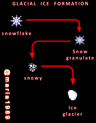
A glacier is constituted by a mass of ice accumulated on dry land with a certain inclination, which for that reason has a tendency to move over the water. This movement, characteristic of the glacier, constitutes at the same time the instrument of erosion. The snow accumulated at high and cold altitudes is progressively compacted and becomes ice. When it begins its downward movement, it erodes the rocks, while transporting a series of materials to finally deposit them at a given point where it melts.
The relationship between the accumulation that occurs and its melting establishes the growth, retreat or equilibrium of a glacier. There are several existing types, but the most common are:
Continental Glacier or Ice Cap or Inlandsis, those classified in this group occupy large areas of land and are permanent, so that they completely cover a certain region; its flow is radial and its surface is planoconvex (having a flat surface and another convex). It is recommended to see Antarctic ice sheet.
Valley glaciers have a very localized accumulation area, within a depression called cirque, from where they flow through a series of valleys that constitute the tongue of the glacier. There are also glaciers unable to overcome their cirque, so they are called cirque glaciers.
.jpg)
”The Columbia Glacier in Alaska shows the anomaly of its concave front, which indicates that the ice melts faster in its central part (which has the greatest volume and depth) for the simple reason that the relatively warm waters of the ocean rapidly melt the front when it reaches sea level.”
The ice erodes the places through which it flows, acting as a giant file. The action of the glaciers gives rise to a characteristic modeling in the valleys, which adopt a "U" shape and are called glacial troughs. These valleys also have a series of typical formations, such as overcut basins, as well as a set of spurs, ridges, etc., which protrude and are located below the basin. When the ice disappears the troughs become lakes. There are other forms, although minor, of erosion, such as the case of the aborregadas rocks, which have their faces rounded and polished as a result of the action of the ice.

In its terminal zone, the glacier forms Moraines, which consist of accumulations of rocks dragged by the ice. If they are found on the margins of the valley walls, they are called lateral moraines, and when they appear in the central areas, they are called central or medium moraines. There are also "morainic" materials on the front side of the tongue, which are called frontal or terminal moraines. When a glacier retreats or disappears, moraines remain; these are characterized by their lack of stratification and their heterometry; the frontal moraines are arch-shaped. Another type of moraine is the bottom moraine, formed by materials that have been transported to the basal zone.

“This map of the balance of changes in mountain glaciers since 1970 shows the decrease in thickness in yellow and red, and the increase in blue.”
In the geographic areas located around glaciers, the so-called Periglacial Regions, most of the characteristics of the landscape are related to the phenomena of glacialism and mechanical erosion, due to the action of ice, as well as to the sedimentation processes derived from melting ice, the transport of materials, etc. When the presence of cold has been prolonged for a long time, the ground has frozen to a depth of several meters, and even to a few tens of meters. For this reason, melting is limited to the summer, and this in a superficial way. The water, unable to penetrate this soil, forms in these periglacial areas permanently muddy or frozen soils, which act as an impermeable layer that prevents any filtration.
.jpg)
“Low and high contrast photographs of Byrd Glacier (Antarctica). The low-contrast version is similar in level of detail to what the eye would see-smooth and nearly featureless. The lower photograph uses increased contrast to highlight flow lines in the ice sheet and lower crevasses.”

ALWAYS THANK YOU
FOR YOUR LOVING CARE !
FOR YOUR LOVING CARE !
Always looking for the motivation to enrich the learning that will strengthen the educational process of humanity, this social network is used as a communication tool in order to bring information to all corners of this globalized world.

I dedicate this report to the educational and cultural training of everyone who knows its importance and respects the value of integral education
❀❀@maria1989
Artículos de consulta (Reference articles):
❀Glaciares (Glaciers / External Geodynamics)❀¿Qué es un Glaciar? (What is a Glacier?)
❀Glaciares (Glaciers)
C r é d i to s (C r e d i t s):
❀ Las imágenes de dominio público fueron reeditadas con las aplicaciones: Paint y PowerPoint, formateadas como archivo PNG❀ The images (public domain) were re-edited with the applications: Paint and PowerPoint, formatted as PNG file.
❀ Se utilizaron los logos de Hive y Ecency
❀ The logos of Hive and Ecency were used.
❀ Todo este material es producto de una investigación universitaria para la Cátedra de Geografía (L.U.Z.), va dirigido al nivel escolar de primaria y también secundaria, para el agrado y satisfacción de quienes estén solicitando dicha información.
❀All this material is the product of a university research for the Chair of Geography (L.U.Z.), it is directed to the primary school level and high school, for the pleasure and satisfaction of those who are requesting this information.
Los glaciales, ya son tan escasos en estos días de calentamiento global que los esfuerzos ecológicos por mantenerlos son inútiles ante tanta contaminación. El glacial del Pico Bolivar ya prácticamente ha desaparecido también, que lastima.
TQM, María has realizado un excelente trabajo de investigación.
Gracias TQM
Beautiful ecological work. Knowing the environment makes create the ecological conscience that all human beings should have, since we all live and share in the same planet.
Excellent @maria1989
Hermoso trabajo ecológico. Conocer el medio ambiente hace crear la conciencia ecologísta que todos los seres humanos debemos tener, ya que todos vivimos y compartimos en el mismo planeta.
Excelente @maria1989
Gracias TQM
Gracias por ofrecernos tan buena información sobre los glaciares, para entender su formación y sus consecuencias sobre el paisaje, así como la belleza natural que proporcionan.
Muy amable y valioso comentario el que usted me ha dejado. Gracias!
Thanks for your contribution to the STEMsocial community. Feel free to join us on discord to get to know the rest of us!
Please consider delegating to the @stemsocial account (85% of the curation rewards are returned).
You may also include @stemsocial as a beneficiary of the rewards of this post to get a stronger support.
Congratulations @maria1989! You have completed the following achievement on the Hive blockchain And have been rewarded with New badge(s)
Your next target is to reach 15000 upvotes.
You can view your badges on your board and compare yourself to others in the Ranking
If you no longer want to receive notifications, reply to this comment with the word
STOPCheck out our last posts:
Support the HiveBuzz project. Vote for our proposal!
Su post ha sido valorado por @ramonycajal