Office of the President 6 Jan 2025https://liberland.org/news/623-liberland-releases-open-source-3d-model-of-its-territory
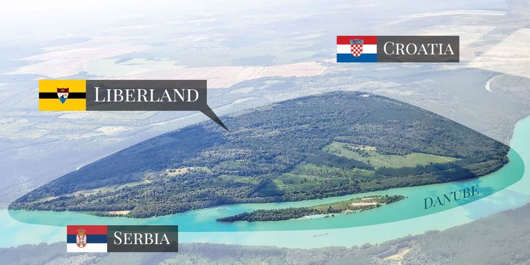
Liberland has taken an extraordinary step in sharing its innovative vision with the world by releasing a high-resolution 3D model of its territory.
This cutting-edge data is now freely available to architects, urban planners, game developers, and other creative professionals under a Creative Commons Attribution (CC BY) license. This means anyone can use the data as long as proper credit is given to Liberland.
You can see the videos of the realized project in this video.
The model is available for you in this Google Drive.
The Foundation: A Technological Breakthrough
The creation of this 3D model is the result of a state-of-the-art drone survey conducted using a DJI Mavic 3 Enterprise drone. The survey employed advanced photogrammetry techniques to map the entire territory of Liberland with a ground sampling distance (GSD) of 7 cm per pixel. Key highlights of the project include:
High-Resolution Scanning:The Liberland area was captured at an impressive resolution of approximately 1.5 cm per pixel.
Multispectral Imaging: Advanced analysis tools, such as the Normalized Difference Vegetation Index (NDVI) and Optimized Soil-Adjusted Vegetation Index (OSAVI), were employed to monitor vegetation health and soil conditions.
These technological feats not only serve Liberland’s urban planning needs but also open doors for broader applications across industries.
What’s Available?
Liberland’s 3D model data is designed to cater to various professional needs. Here’s what you can access:
Textured 3D Mesh
File Formats: OBJ, FBX
Applications: Perfect for visualizing projects, creating immersive environments in virtual reality, or game development.
Recommended Tool: Blender, a free and powerful 3D modeling tool.
Colored Point Cloud
File Format: LAS
Applications: Architects and urban planners can use this data for highly detailed spatial analysis and design.
Recommended Tool: CloudCompare, a specialized software for point cloud analysis.
Orthophoto
File Format: TIF
Applications: Ideal for large-scale visualizations and integrations into CAD or Photoshop for detailed mapping and planning.
Who Can Benefit?
The uses of Liberland’s data are as diverse as its potential audience. Here are some of the key sectors that stand to gain:
Architecture: Design site-specific projects with unparalleled precision using the 3D mesh and point cloud data.
Urban Planning: Optimize land use, plan infrastructure, and create innovative layouts for sustainable development.
Gaming and Virtual Reality: Integrate Liberland’s textured 3D models into immersive games or virtual environments to captivate users.
Beyond these fields, the data also serves environmental researchers, infrastructure developers, educators, and even marketers. From assessing soil fertility to creating promotional visuals, the possibilities are vast.
Aligning with Liberland’s Vision
This project is not just about providing data; it aligns with Liberland’s broader goals of innovation and accessibility. The 3D models are part of the nation’s digital cadastre mapping initiative and serve as the foundation for its virtual metaverse. By merging cutting-edge technology with real-world applications, Liberland is setting a precedent for digital urbanism.
Moreover, this initiative reflects Liberland’s commitment to fostering collaboration and creativity on a global scale. The availability of such detailed and versatile data positions Liberland as a leader in modern urban development and digital integration.
An Invitation to Liberland
By releasing this high-resolution 3D model, Liberland invites architects, planners, and developers worldwide to participate in its vision. Whether you’re designing a futuristic cityscape, building a sustainable urban plan, or creating the next big game, this data is now yours to explore. Do you wish to use the model? Please write us at [email protected].
This bold move not only highlights Liberland’s forward-thinking approach but also underscores its commitment to openness, innovation, and community. The possibilities are limitless, and the tools are in your hands.