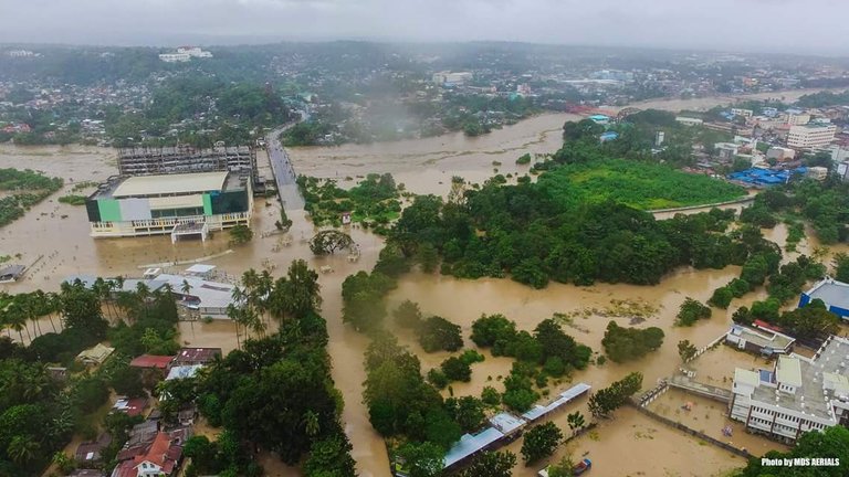
An aerial photo of part of Cagayan de Oro City that is flooding as of this moment, 22 December 2017, 10am.
SEVERE WEATHER BULLETIN #13
Tropical Cyclone: WARNING
FOR: Tropical Storm #VintaPH
ISSUED AT: 11:00 AM, 22 December 2017
Tropical Storm #VintaPH has slightly weakened while traversing the northern part of Davao Region
Scattered to widespread moderate to heavy rains will prevail over Visayas and Mindanao within 24 hours.
Residents of these areas must make appropriate actions against flooding and landslides, coordinate with their respective local disaster risk reduction and management offices, and continue monitoring for updates.
Sea travel remains risky over the seaboards of areas under Tropical Cyclone Warning Signal (TCWS).
Strength: Maximum sustained winds of 80 kph near the center and gustiness of up to 130 kph
Forecast Movement: Forecast to move West at 18 kphLocation of eye/center: At 10:00 AM today, the center of Tropical Storm #VintaPH was estimated based on all available data including Hinatuan Doppler Radar In the vicinity of Malaybalay City, Bukidnon (08.2 °N, 125.2 °E)
Forecast Positions:
24 Hour(Tomorrow morning): 170 km North Northwest of Zamboanga City, Zamboanga del Sur(8.2°N, 121.3°E)
48 Hour(Sunday morning): 260 km Southwest of Puerto Princesa City, Palawan(8.4°N, 116.8°E)
72 Hour(Monday morning): 340 km Southwest of Pagasa Island, Palawan(8.9°N, 111.9°E)
TROPICAL CYCLONE WARNING SIGNAL
TCWS#2 (61-120kph expected in 24 hrs)
Agusan del Sur, Davao del Norte, North Cotabato, Misamis Oriental, Bukidnon, Lanao del Norte, Lanao del Sur, Misamis Occidental, Zamboanga del Norte, Zamboanga del Sur, and Zamboanga Sibugay
TCWS#1 (30-60kph expected in 36 hrs)
Southern Leyte, Bohol, Southern Cebu, Negros Oriental, Southern Negros Occidental, Siquijor, Dinagat Island, Surigao del Norte, Surigao del Sur, Agusan del Norte, Camiguin, Compostela Valley, Davao Oriental, Davao del Sur, Maguindanao, Sultan Kudarat, and Basilan.
I hope everyone is safe please pray for us