During my research work at Federal School of Surveying studying Geographic Information Systems, I was able to study how GIS could be used for emergency purposes such as Best Route , Shortest Route, Closest Facility and Service Area.
Both geographic information systems (GIS) and network analysis are burgeoning fields, characterized by rapid methodological and scientific advances in recent years. A geographic information system (GIS) is a digital computer application designed for the capture, storage, manipulation, analysis and display of geographic information. Geographic location is the element that distinguishes geographic information from all other types of information. Without location, data are termed to be non-spatial and would have little value within a GIS. Location is, thus, the basis for many benefits of GIS: the ability to map, the ability to measure distances and the ability to tie different kinds of information together because they refer to the same area.
Roads are often built in comparatively undeveloped areas, which are not necessarily inhabited to stimulate their development and potential economic growth
There are several means of transportation; these are land, water and air. Land transportation accounts for about 90% of all the means of transportation in Nigeria.
Road transportation network development is considered to be one of the keys to rapid modernization and development, especially in most development countries, investment for road construction and maintenance accounts for a substantial (excess of 20%) of development budgets. Road network provide accessibility and easy flow of traffic for both human being and movement of vehicles. It is discovered in our urban cities/towns the difficulties in accessibility and transportation of goods, services from one place to another due to inadequate planning and uncoordinated development planning which greatly affect access to some neigbourhood and facilities.
Road networks being the main network most country use, GIS concept like connectivity and accessibility could be used to enhance the opportunities available for the people and services providers to access places where they can carry out activities and even to foster development in the choice area.
A network is a set of connected line features that form a pattern. Network of roads provides accessibility or easy movement of the resource or person from one location to the other on the earth surface. A road network consists of multiple connected lines and one of the Geographic Information System major strength is the ability to perform numerous operations on networks. Data acquisition for the road network can be accompanied by making use of remote sensing, digital photogrammetry, and also from secondary data sources. Non- spatial attributes data can also be acquired for the road network and existing facilities.
An emergency is a deviation from planned or expected behavior or a course of events that endangers or adversely affects people, property, or the environment.
Response refers to activities following an emergency or disaster. These activities are designed to provide emergency assistance for victims (for example, search and rescue operations). They also seek to stabilize the situation and reduce the probability of secondary damage to speed recovery operations.
Geographic information systems are computer based to capture, stores, check, integrate, maintain, analyze and display geographic information which can be related to a specific location or portion on the earth surface. Spatial information covers a large range of decision-making and is capable of linking description of location with characteristics of the features found such as road the road network.
With the availability of GIS technology which enables data acquisition, database management and information presentation; it is possible to capture location, attributes data of each of the road forming the network of the roads and access to the nearest facilities within the study area. A good road network provides accessibility which goes a long way to improve the quality of life and social economic well-being proficiency of the society in all ramifications. Accessibility concept measure how accessible one location is to other location and how closer and fast is facility to you; all this accessibility is good road network.
Efficient routing is a major requirement for many businesses and services, especially for emergency responses such as ambulance carrying a patient to the hospital on emergency. However, a digital database should be able to answer some basic generic question about location, routing and condition.

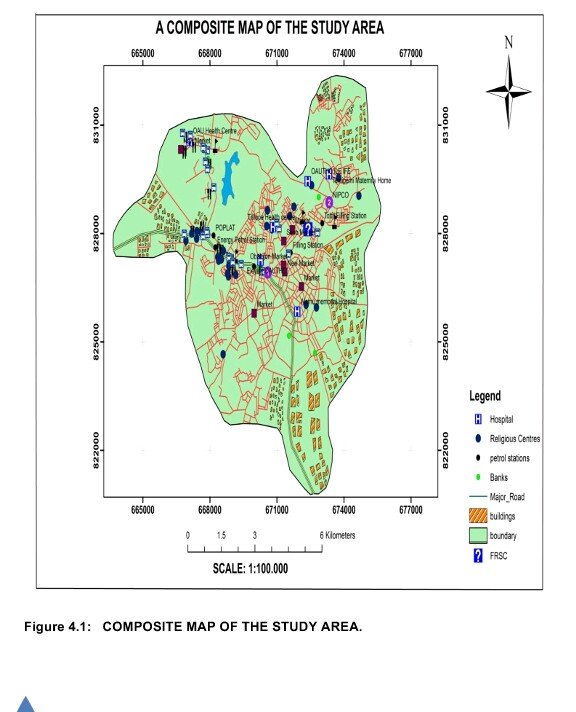
This is the composite map of the town and it shows some important features such as the hospital, FRSC, Filling stslations and so on.

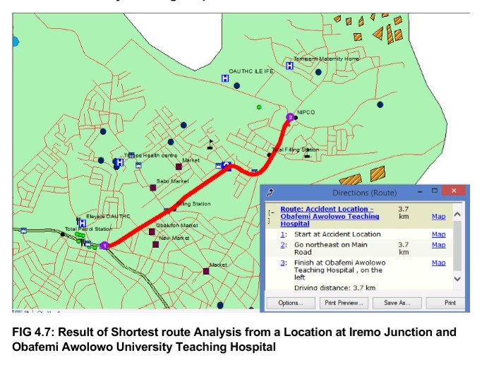
This shows the shortest route between one point and the other.
Geographic Info Systems is a very good tool being used in emergency and the software used for the research work is Arcgis software.
Technology has really gone a long way in locating places and tracking down locations as a result of GIS. GIS has made life easier for tourists and travellers, in the sense that you can visit a place you have never visited before with the aid of map on devices. #OWB
True indeed, definitely has practical in addition to EMS value!
Very excellent points! Roads are the "arteries" of city-planning.
RE: "Road transportation network development is considered to be one of the keys to rapid modernization and development, especially in most development countries, investment for road construction and maintenance accounts for a substantial (excess of 20%) of development budgets. Road network provide accessibility and easy flow of traffic for both human being and movement of vehicles. It is discovered in our urban cities/towns the difficulties in accessibility and transportation of goods, services from one place to another due to inadequate planning and uncoordinated development planning which greatly affect access to some neigbourhood and facilities.
Road networks being the main network most country use, GIS concept like connectivity and accessibility could be used to enhance the opportunities available for the people and services providers to access places where they can carry out activities and even to foster development in the choice area."