The name Hurricane is derived from the Carib Indian's name Hurican, which translates to the god of evil. You may agree with the aptness of the name if you've witnessed one in action. The Caribs are the dominant tribe of people living in Central America part of Dominica, of which the Carribean owes its name to this tribe.
Imagine a wind and storm so powerful that the spinning wind exceeds a speed of 185 miles per hour ( 297 kilometres per hour). At that ferocious speed, houses and things that lies on their paths are set up for total obliteration. If you could imagine such a scenario happening in real life, you have just imagined a hurricane.
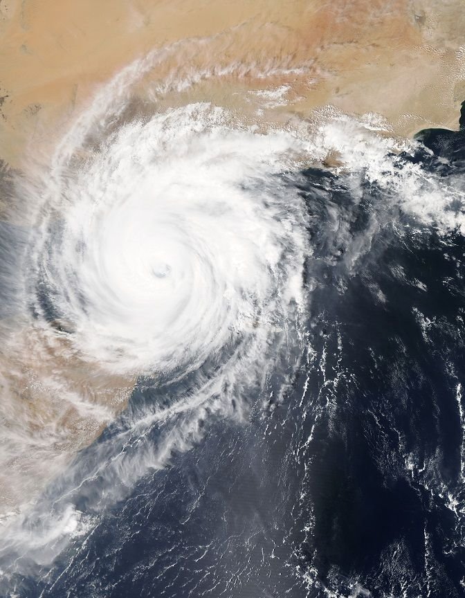
Photo by NASA on Unsplash: A Hurricane
A hurricane is a special type of tropical storm that swirls with accompanying wind speeds of 74mph (119kmh) or more.
There are similarities between a hurricane, a cyclone or a typhoon. A tropical cyclone has the same property of a hurricane; it comes with a swirling or rotating wind property. The only difference is its speed is less than 74 miles per hour. If a tropical cyclone hits a wind speed of up to 34mph, it is now a tropical storm.
The typhoon is just the same as a hurricane but occurs over the Northwest Pacific Ocean. Whereas, the hurricanes are formed over the Northeast Pacific and North Atlantic Ocean.
Apart from the speed, cyclones also occur over the Southern Pacific Ocean and the Indian Ocean.
The making of a hurricane
We all know how large and devastating a hurricane could be. A hurricane at its peak can cover up to 100 miles (160km). The inside of the hurricane, which constitutes of "walls" of ice and clouds, extends upwards to about 10 miles (16 km).
[Wikipedia]Source
To have these dynamics at play which results in a hurricane two physical phenomena work together to achieve that. They are the heat and wind.
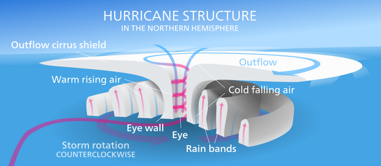
The heat effect
The winds flow towards the centre or eye of the hurricane. Under normal circumstances, due to the low pressure of the area, the breeze will cool that part. But due to the ongoing massive evaporation, each gallon that evaporates has the thermal energy property of one cup of petrol. Remember evaporation causes cooling as it takes heat away. The evaporated water condenses in the atmosphere.
The evaporation continues with the upward movement of moist air. This updraft creates a low-pressure point. Wind from the high-pressure part of the atmosphere gets sucked into this low-pressure section.
The rising moist air condenses and feeds more energy to the air creating more clouds and rains.
The spinning effect of wind due to Coriolis Effect sets in along the line. Coriolis Effect is the spinning effect of the earth on wind direction.
At about 40,000 feet, cold, dry air forced from the storm's peak sinks downwards in the storm following the eye of the storm. This creates an area that is devoid of rain.
The Power Monster
A well-formed hurricane has the capability of producing 1.5cm/day rain through a 665km radius. The thermal energy equivalent (energy expended during evaporation of water) is a massive 6.0 x 10¹⁴ Watts or 5.2 x 10¹⁹ Joules per day.
This thermal energy generated is equivalent energy that is 200 times the required world's energy according to the National Oceanic and Atmospheric Administration website on hurricane matters here.
Or according to NASA.
during its life cycle a hurricane can expend as much energy as 10,000 nuclear bombs!NASA
The destruction of lives and properties due to sea surges and flooding makes hurricanes a dreaded natural disaster. For instance in 1998, Hurricane Mitch left about 18,000 dead in 1998 in Central America.
Weather 101
The pressure of the atmosphere plays an essential part in the weather of the day. Listening to the weather forecast you may hear the weatherman make mention of a particular area as low-pressure point and thus to expect rain or a high-pressure point to have beautiful weather.
This forecast is based on how pressure (high or low) affects air.
Air flows from the region of high pressure to the area of low pressure. The wind blows in the direction of the low pressure, and air that rises makes the moist water to form condensation creating precipitation. These low-pressure points are marked with a red "L" on a weather map.
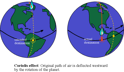
Due to earth's rotation and Coriolis Effect, the low-pressure winds deflect and swirls anti-clockwise for winds in the North of the Equator and clockwise direction to the South of the equator. This phenomenon is known as the cyclonic flow.
If it is a high-pressure system, wind behaves the opposite and blows away from the high-pressure area. The direction of flow also reverses: anticlockwise for the South of the equator and clockwise for the North of the equator. This high-pressure point is usually depicted by a blue "H" in the weather map.
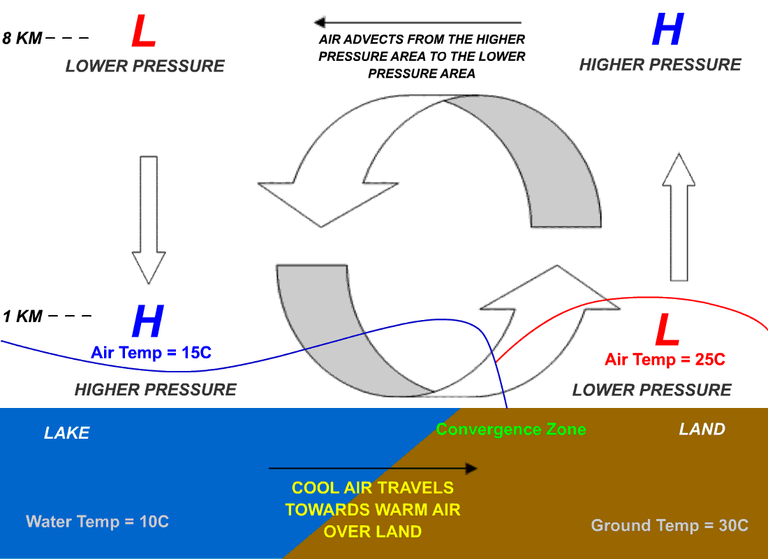
[Wikipedia]Source: The weather formation
The wind migration from the area of low pressure to an area of high pressure results in the massive winds that are the hallmarks of every hurricane.
The swirling hurricane's wind follows the Coriolis Effect of produced by the Earth's spin. If the earth were to be stationary, the wind of the hurricane would move in a straight line.
The 74-mile+ speed wind blowing along the North of the equator also has some elements of it blowing Eastward (the Earth's rotation path), so it apparently gets deflected to the right or the east.
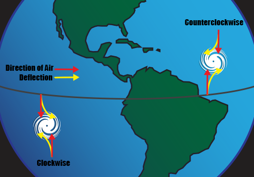
The opposite is what happens when the air moves towards the South of the equator and encounters a faster surface speed. It deflects westward or to the left.
This wind's defection according to the earth's rotation is how the Coriolis effects give the storm its swirling effect. That also explains the difference in direction. The cyclones spin at the anticlockwise direction in the Northern hemisphere and rotate clockwise in the Southern hemisphere.
Hurricanes hardly form at the equator because of this too. This lack of hurricane formation is due to the insufficient difference in the rotation that is apparent at those low latitudes of the equator.
For more pictorial representation of this explanation check this picture here.
Image Reference
Image 1: Coriolos Effect
Image 2: Coriolis Effect Showing Clockwise and Anticlockwise effects
References
A Brief History of Hurricane's Name
Hurricane, Cyclone and Typhoon
Energy of a Hurricane
Anatomy of a Hurricane
hereblog@steemstem here and this guidelinesIf you write STEM (Science, Technology, Engineering, and Mathematics) related posts, consider joining #steemSTEM on steemit chat or discord . If you are from Nigeria, you may want to include the #stemng tag in your post. You can visit this by @stemng for more details. You can also check this blog post by here for help on how to be a member of @steemstem.

The hurricanes are in tropical regions where the waters are warm (27 ° C), the air is damp and the equator winds converge. Most Atlantic hurricanes start with a thunderstorm in the western coast of Africa and move towards warm tropical ocean waters. This thunderstorm turns into a hurricane in three stages:
Tropical low pressure - rotating clouds and rain, the speed of the wind is under 38 miles per hour.
Tropical storm - from 39 to 74 mph winds.
Hurricanes - winds that are greater than 74 degrees per hour.
The thunderstorm turns into a hurricane for a few hours to a few days. Although the reasons for the formation of the whirlwind are still not completely known, the following three events must occur in the whirlwind formation:
Thanks for that insightful addition to the topic of discussion. It's much appreciated.
I hope you like it...I follow your senders very successfully @greenrun 🙏
Read about this sometime ago when I was writing an article on how hurricanes get their names. Before then I thought all storms moving with high velocities were hurricanes.
It is always fascinating to see how all these work. Thank you.
What an expose on hurricane. I am glad Africa does not have it to that extent. Its effect is terrible. Thank you for this information @greenrun
We have our own problems even though due to location we may not have as much hurricanes as those near the India and Pacific Oceans due to easterly winds carrying the hurricanes away from the Atlantic Ocean.
wow..wow...wow..!!! what nice and wonderful post. i like your Hurricane: The Storm with the Winds of Fury post. thanks for share the post.
Thank you!
Just learnt more about hurricane Visiting your blog, thanks for educating me the more. Keep sharing your knowledge.
Thanks @blinks.
great information and also helpful
thanks for sharing
Thank you for reading.
So much to learn given that i only studied elementary geography in secondary school. And growing up in Nigeria, we don't get to experience this weather condition.
The location of the country and the wind direction helps to that effect. Thanks.
Interesting facts. I think I've learned some new things from this post. Thanks for sharing!
You are most welcome. Thank you too.
Never knew the swirling effect of an hurricane was caused by the rotation of the earth. So many terminologies i haven't even heard of,thanks for this post. I now know so much about hurricane. The aftermath of an hurricane is so terrible
We all learn from each other here. Thanks for taking out time to read.
Hurricane is the denjarous. Storm .It is destroy your village and city..
That is true. Thank you.
Wow..I've never experienced one before, only watched on TV and my goodness the name"god of evil" gives me the chill..lol. nice one @greenrun.
Better to watch it on TV than to witness one. Thank you.
In this part of the world, we are very blessed not to have witnessed hurricane. My heart goes out to the victims of this natural disaster..
Hurricanes are serious natural disasters, like I told @gloeze, we still have storms and floods to contend with even though there's not much hurricanes here. Thanks for reading.
Owk this is a very informative one as usual ...keep it up @greenrun
Thanks a lot.
i watched one documentary about hurricane on YouTube, and its not usually a funny site to behold but if i may ask, is it possible to predict when this hurricane will happen just like earth quakes?
Hurricanes can be predicted and advanced warning issued. That is the work of the meteorologists who has help from the Doppler radar and satellite images.
Last year September, people of Florida were warned to leave during Hurricane Irma. Some days later, Hurricane Irma hits Florida.
I follow you. Plz follow me!
Thanks for the follow.
information that is very useful for us to share.
thank you..
Thank you!
I followed u. Plz follow me/
Your style of approach to this topic is succinct. Before now, I have no idea of what leads to this destructive wind flow Called hurricane. But have a question...
Does this deference arises as a result of difference in air densities of the component gases?
Upv by
@eurogee, the Steemivangelist
Thanks for the upvote . I think it is to do with the how particles behave in both low and high pressure environment. In high pressure region, particles experiences more force. This force helps push it into the lower pressure area since the force present in particles in higher pressure environment could easily overwhelm force acting on particles in lower pressure area.
Your article is good to read. There is a lot of information in this.
I love watching hurricane and storm chasing videos. I have no idea why so this post is just perfect.
Also, living near the equator I witnessed the Coriolis Effect where we poured water in a bowl two different points and the water flowed in different directions.
Image
Yeah, there are people who enjoy doing storm chasing. A dangerous sport as one may be caught right in the middle of one. Thanks for the insightful comment.
Outstanding write of the hurricane
Kudos boss 👍👍
Thank you
The devastation The God of Evil causes sure suits its name !
I agree with you. Thank you.
Expository post on hurricane bro.
On a humorous note; why do they always name hurricane after people? (Hurricane katrina, Hurricane mitch, Hurricane Cindy, Hurricane Franklin, etc) I need to check if there's Hurricane Samminator :)
Lol :)
Check and get back to us
Yehh!! I did; and there's no "hurricane Samminator" yet :D
Hello greenrun,i am really fasicnated with your work,i have started following you and i hope to view more impressive work from you.
Thanks for the follow :)
In your ozone post you talked about how the air pressure gets lower the further away from the planet it is. As the gravity is more or less the same all around Earth how do we get the low pressure close enough to the world to create hurricanes?
In addition Hurricanes rotate in a counter-clockwise direction around the eye. The rotating storm clouds create the "eye wall," which is the most destructive part of the storm.
Hurricanes form over warm ocean waters near the equator. The warm, moist air above the ocean surface rises, causing air from surrounding areas to be “sucked” in. This “new” air then becomes warm and moist, and rises, too, beginning a continuous cycle that forms clouds. The clouds then rotate with the spin of the Earth. If there is enough warm water to feed the storm, a hurricane forms!
Please always indicate quoted source as I can see you quoted from here http://10thingslife.com/10-facts-hurricanes/
Thanks a lot.
Everyone hates hurricane. The destruction it causes are massive.