Alright folks, its so good to be here again to demystify what might have been somewhat like a silent question in our minds, we would be talking about GPS today and i know loads of insight would come out of it, so sit back as you read and learn.
It’s become highly important to have a system via which we can pinpoint the exact location of anyone and anything in space. At first, we had Navigation systems via which we could locate anything static e.g houses, lands mountains etc.
Maps are quite static is like even as Space is static. Space is 3-dimensional which in itself cant account for positions of moving quantities e.g. (humans cargos ships and automobile) a means via which we can factor in a fourth dimension (Time) would make us able to pinpoint any object moving in 4th dimension, the fourth dimension being time.
Due to advanced GPS technology, The possibility of getting lost in whatever place I am going to is less, since I have my mobile device which also acts as a GPS receiver and gives me an accurate identification of my real time location relative with the map of that area simultaneously. Thus I know where I am now and can see what direction I can take to get to where I am going fastest. The fact remains that wherever I am, I can be found even if I find y self in the middle of the Atlantic ocean, I will still be located, but how does this operate?
EVER HEARD OF SATELLITE NAVIGATION?
Satellite Navigation is the process via which radio receiver is used to pick up e-m signals from orbiting satelites mounted on space. So for satellite navigation to work, your receiver must pick out signals from a satellite in space to accurately figure out your location in space, generally speaking.
The satellite navigation is the most accurate navigation system in existence now. As of now the best Satellite Navigation used so far is known as NAVSTAR positioning system which has a 2-4-7 active time, the Navstar has about 24 orbiting satellite in space, which is enough to you know, cover the earth such that no location in the earth would be unknown.
At this juncture, its note-worthy to note that the GPS is not the only satellite Navigation system, however, it is the most accurate. There are also other systems owned by other countries… OH!! I haven’t mentioned, the GPS is owned by the United States of America and is the most efficient navigation system, of course, they are the ones using the Navstar, Russia also has its navigation system called GLONASS which has also reached global coverage however certain countries like China and even the European Union is yet to reach global coverage, it is predicted that the European Union’s Galileo system would reach global coverage by 2019.
The GPS was birthed by the US Military during the cold war, now this gave them the ability to get the precise location of targets when they want to launch missiles. In using submarines to launch a missile, it's very important to identify the precise location of that submarine. For accurate calculation and triangulation, the GPS system, therefore, came in handy to that effect.
SO HOW EXACTLY IS A LOCATION KNOWN VIA GPS TECH
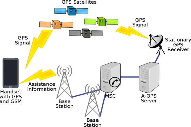
So how does this system operate in particular? The first thing we need to note is that there are 3 major components of GPS, The Satellites in space, the Antennas and controlling stations on the ground and certainly the GPS receiver in your pocket, with these three components in place it is very anything can be located at any time.
Schematic of the whole Global position system(
The satellites are orbiting and mounted in space, for global coverage of location we need about 24 satellites up there like Navstar discussed earlier, these satelites simply transmit signals, for GPS there are currently about 32 sattelites mounted in space, though only 24 is needed but due to the fact that their life-span is only about 10 years and there is constant need for servicing of these sattelites, the extra satellites are used to fill in the gap.
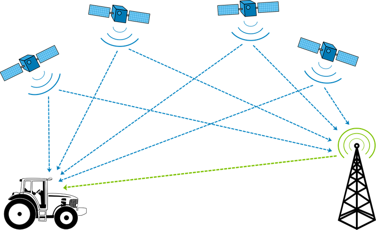
The control stations are majorly used to control the satellite to make sure they are in good shape and as a means of troubleshooting whatever might be wrong with them. Ultimately we have the receiver, which is usually the component in your pocket as your mobile phone or any other GPS enabled device, how the device works is quite simple, it receives signals from the satellites in space, to get a precise location, the receiver has to receive a signal from at least 3-4 satellites.

Pixabay under CCO license: Image of how a car is triangulated by 4 orbiting satellites
The satellites being at a known position (constant) sends high speed electromagnetic signals to the receiver containing 2 things, its position and the time component for which the signal was transmitted,. Getting at least 3 of these would supply the receiver with 3 -4 different set of unknowns being (x,y,z) coordinate l dont let's forget the 4th dimension in space which Is time (t) the receiver develops these set of equations and on solving it, we have a result, these result gives us the exact location of the GPS carrier. The receiver actually develops this equation set by noting the time taken for each of these signals to arrive and the distance between itself and the satellites.
Lets look at it this way, Speed= Distance/Time taken
This is how it works.
For the speed... Its constant as the speed of light.
Part of the information from the satellite is the timestamp of when the signal left it and the receiver takes note of when the signal reached it thereby computes the time difference, these would certainly give the receiver an insight to its distance from the satellite, if such happens with about 3-4 sattelite it should be able to figure out its location in space and time, It might not also be safe to say that the radiowaves travelling from space is traveling at lights speed through out.
That’s because of the medium through which it travels, while in space we can say it has its full speed seeing that it is travelling in a vacuum but on reaching the earths atmosphere, this speed tends to be deviated and its speed tends to be altered. The receiver is therefore configured to compensate for these laps in order to bring out an accurate result.
Two major spheres that influences the travelling waves are the atmosphere and the troposphere, seeing that the atmosphere is dense with charged particles and hence helps the travelling wave, The troposphere on the other hand is an uncharged region/sphere and tberefore distorts the speed through which these signals travels in the earth.
If the GPS was developed by the military for the military, why then are Civilians using it?
Yea, its very true that the GPS was originally designed for the military for accurate launching of missiles and also for triangulation. But sooner or later, it was discovered that Civilians would also find this piece of Tech handy.
But you know, giving it to civilians meant giving it to the world, and therefore teir edge over the world is reduced, So this is what they did, they simply developed 2 types of GPS. The first one is known as the PPS (Precise Positioning Service) and the other known as SPS (Standard positioning service). While the PPS gave a precise location Of receivers, the SPS accuracy was degraded to about 5 times the original accuracy. But you know what, that didn’t hold for long, In May 2000, the US government made SPS receivers highly accurate, this innovation made GPS highly accepted around the globe.
GPS.gov Tells us that there is seemingly no difference in the accuracy of Civilians GPS and Military GPS, however, their GPS uses 2 frequencies of transmission while the Civiians uses only one frequency.
While there is accuracy at the end GPS satellite transmission, it might also be safe to note that this doesn’t mean account for the transmission deficieny in the medium of propagation, blocked signals or even degraded receivers, that means you GPS might not at all time give you the desired triangulation.
Also that your GPS is working well doesn’t mean your map was drawn correctly, you see, lots of things need to be factored into the design.
CONCLUSION : GPS IN MY FUTURE
Its great to know my location in space now, via the use of GPS, but that might be a myopic application of what GPS can actually do, ever thought of how self driving cars can take me to my desired location? GPS of course, all though lots of AI still needs to be factored into the software design but the already established GPS would come in handy in the development of such tech. Yea Self driving cars even exists now but not in my present, because I haven’t used one before so permit me to say… In my future.
REFERENCES
https://spaceplace.nasa.gov/gps/en/
6 things you didnt know about GPS
If you write STEM (Science, Technology, Engineering, and Mathematics) related posts, consider joining #steemSTEM on steemit chat or discord here. If you are from Nigeria, you may want to include the #stemng tag in your post. You can visit this blog by @stemng for more details.

You can also join us at Promo-Mentors, to improve your blogging skills. Join our discord channel and meet awesome mentors who are willing and ready to shape your writing skills.


Hello! I find your post valuable for the wafrica community! Thanks for the great post! We encourage and support quality contents and projects from the West African region.
Do you have a suggestion, concern or want to appear as a guest author on WAfrica, join our discord server and discuss with a member of our curation team.
Don't forget to join us every Sunday by 20:30GMT for our Sunday WAFRO party on our discord channel. Thank you.
Congratulations @lawkay! You have completed the following achievement on the Steem blockchain and have been rewarded with new badge(s) :
Click on the badge to view your Board of Honor.
If you no longer want to receive notifications, reply to this comment with the word
STOPDo not miss the last post from @steemitboard:
This post has been voted on by the steemstem curation team and voting trail.
There is more to SteemSTEM than just writing posts, check here for some more tips on being a community member. You can also join our discord here to get to know the rest of the community!
Hi @lawkay!
Your post was upvoted by utopian.io in cooperation with steemstem - supporting knowledge, innovation and technological advancement on the Steem Blockchain.
Contribute to Open Source with utopian.io
Learn how to contribute on our website and join the new open source economy.
Want to chat? Join the Utopian Community on Discord https://discord.gg/h52nFrV