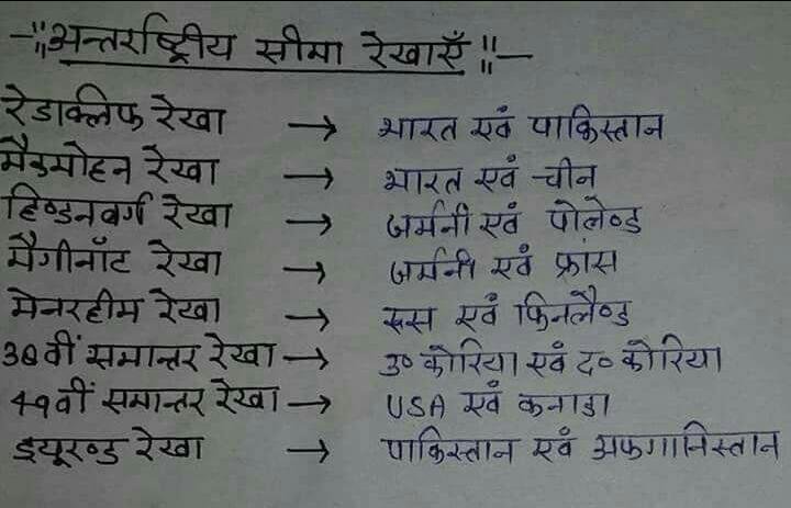
- The Radcliffe line india v/s Pakistan
The Radcliffe line became a boundary between India and Pakistan after the Partition of India on August 17, 1947. The line was determined by the Border Commission, headed by Sir Cyril Radcliffe, who was authorized to divide 175,000 square miles of area between 88 million people.
2 . Macmohan Line India and Chine
The McMahon Line is the boundary between India and Tibet. It came into existence in 1914 under the Simla Agreement between India's then British Government and Tibet. For the next several years since 1914, the existence of this boundary was concealed somewhere due to many other disputes, but in 1935, an English Administrative Officer, Olaf Kero, requested the then British Government to officially implement it. In the Map of the survey of India in 1937, the McMahon Line was shown as the official Indian borderline.
The name of this boundary was named after Sir Henry McMahon, who had an important role in this agreement and he was the Foreign Secretary of India's then British Government. Most of the Himalayas, the boundary line extends from Bhutan in the west to 890 km and to east of Brahmaputra up to 260 km. Where India has its boundary with China accordingly, China denies the 1914 Shimla agreement. According to China, Tibet was not an autonomous state and he had no right to make any kind of agreement. In the official maps of China, the area of 56 thousand square miles south of the McMahon Line is considered to be part of the Tibetan Autonomous Region. This region is known as Southern Tibet in China. During the Indo-China war of 1962-63, Chinese forces had also acquired rights on this area for some time. For this reason, the dispute remains on the boundary line till the present time.
- The Hindenburg Line German and Polland
The Hindenburg line was the German defensive position of the First World War, which was made on the Western front during the winter of 1 916-19 17, from Erus to Lafox, on the eve of Soinecenes. In 1916, the German invader was an expensive failure in the battle of Vardun.
- The Maginot Line
The Maginot Line named after the French Minister of War, André Maginot, was a line of concrete fortifications, obstacles, and weapon installations built by France in the 1930s to deter invasion by Germany and force them to move around the fortifications. Constructed on the French side of its borders with Italy, Switzerland, Germany, and Luxembourg, the line did not extend to the English Channel due to French strategy that envisioned a move in Belgium to counter a German assault.
Based on France's experience with the terrain warfare during World War I, the massive Maginot Line was built in the run-up to World War II, after the Locarno Conference was given a fanciful and optimistic "Locarno spirit". French military experts extolled the Line as a work of genius that would have been the German aggression, because it would slow the invasion force long enough for French forces to mobilize and counterattack.
Next four Line next blog 😊😊
Thanks every support me and follow me .
@Lalitswami