Repository
https://github.com/vanarchist/vanlife-spot-finder
Details
This development task request outlines the functionality of a weather overlay feature. Appropriate weather is important for selection and planning of spots to camp at for many vehicle dwellers. Many don't have heaters or airconditioners and rely on the local weather as the thermostat. Additionally, precipitation can create impassable roads and lead to being stuck somewhere or unable to get to a spot, especially on the dirt backroads. The weather overlay feature will allow quick visual identification of appropriate weather conditions as specified by user input from historical data.
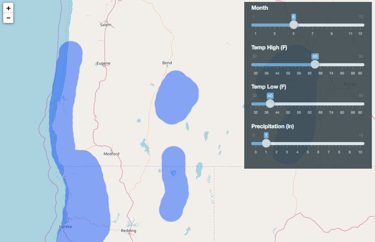
The following mockup demonstrates what the proposed feature will look like when implemented.

The example shows a polygon overlay indicating the areas on the map where the user specified weather parameters have been satisifed based on interpolated data from the NOAA monthly weather normals. In this case, for the month of May the average high temperature is <= 65 F, the average low temperature is >= 40 F, and the precipitation is <= 1 in in the blue areas overlayed on the map (Note that the data is made up here). A possible expansion of this feature is to allow toggling between actual realtime weather including solar index in addition to historical averages. The base implementation however will just use historical data to enable more efficient seasonal migration planning.
Components
This feature will require changes to the map view, control box, and data software components.
Map View
The map view will have semi transparent shapes overlayed which indicate the areas where the user specified weather parameters have been satisfied.
Control Box
The control box will have slider controls added as shown in the mockup for month, average high temperature, average low temperature, and precipitation. An appropriate menu navigation scheme should also be devised for displaying this weather parameter data from the main menu.
Data
NOAA normals for monthly averages will be used as the data source for this weather overlay feature. The data is avialable from the NOAA website and will need to be imported for application use. SQLite/Spatialite should be used for the datastore unless a better option is identified. Spatial interpolation will need to be performed in order to generate the overlay graphics.
Deadline
The deadline is 6/30/18. Get in touch if you want to work on it.
Communication
You can get in touch through steemit, github, or e-mail me at [email protected].
Thanks for the task request. It has been approved.
Chat with us on Discord.
[utopian-moderator]Need help? Write a ticket on https://support.utopian.io/.
Hey @vanarchist
We're already looking forward to your next contribution!
Contributing on Utopian
Learn how to contribute on our website or by watching this tutorial on Youtube.
Utopian Witness!
Vote for Utopian Witness! We are made of developers, system administrators, entrepreneurs, artists, content creators, thinkers. We embrace every nationality, mindset and belief.
Want to chat? Join us on Discord https://discord.gg/h52nFrV
Nice job! We need this for Europe too.
Thanks, I'll add it to the priority list. Currently working on improving the database and getting more data into it.