Happy Tuesday! In the US, hurricanes and tropical storms tend to graze the coastal areas, but every now and then we'll get a good storm come straight up from the Gulf of Mexico, the remnants of which bring plenty of rain, wind, and storms through the southern and 'midwestern' states. Such is the case right now. I'll use this event to share a cool activity with NOAA weather satellites that anyone can get involved with, anywhere in the world, with minimal resources.
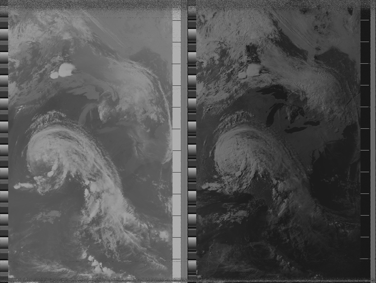
This is an image that was captured here at my home, from a NOAA satellite (NOAA 15), at 2020-06-09 00:24 UTC. Those familiar with US geography can see the Great Lakes with Tropical Depression Cristobal parked over the state of Arkansas. It may help to compare this image with the forecast map:

Anybody in the world can receive satellite imagery from these weather satellites as they pass overhead.
I'm not going to go into a tutorial on how to do so here because there are plenty of them available online (I'll link below) but this is a fun entry into weather, satellites, and radio combined.
At a minimum you need some kind of computer to do the recording and decoding (a PC, laptop, or even a raspberry pi will work fine), and you need a radio source that can receive the 137 MHz signal without distortion. Nowadays, software defined radios are inexpensive and there is plenty of software for them. Start with the low-cost RTLSDR. The last piece you need is some kind of antenna, and your the quality of your results will vary based on the quality and capabilities of your antenna. Antennas can be bought or made, and there are lots of designs out there, some included in the tutorial. Build yourself a simple antenna, decode your first image, and make improvements over time! Your initial results will likely be faded, grainy, or have lots of static. That's okay - get a taste for the results and challenge yourself to improve on the reception.
The best tutorial can be found on the RTL-SDR blog here. To be transparent, they do sell their own brand of RTLSDR based receiver dongle, and they work really well, but any make and brand should work.
Keep in mind that the NOAA satellites are moving in orbit, and will not always be overhead. You have to find out when a certain satellite will pass overhead and what its frequency will be. The tutorial describes using an application to track where the satellites are and tell when they will pass by your location.
There are video tutorials as well if you want a different approach.
Advanced users may wish to automate this process by building a SatNOGS ground station - but that will come in a later post.
For more information, the RTLSDR blog has a lot of great posts on this topic under the APT and NOAA tags (APT is the type of signal used to relay this imagery data).
Cheers!

Hey @steevc, have another @tenkminnows candidate for you
Thanks Josh!
Added!
Congratulations @cshields! You have completed the following achievement on the Hive blockchain and have been rewarded with new badge(s) :
You can view your badges on your board And compare to others on the Ranking
If you no longer want to receive notifications, reply to this comment with the word
STOPTo support your work, I also upvoted your post!
Support the HiveBuzz project. Vote for our proposal!