ZCZC MIATCPEP2 ALL
TTAA00 KNHC DDHHMM
BULLETIN
Tropical Storm Norma Intermediate Advisory Number 11A
NWS National Hurricane Center Miami FL EP172017
1200 AM MDT Sun Sep 17 2017
...NORMA EXPECTED TO TURN TOWARD THE NORTH-NORTHWEST LATER TODAY...
SUMMARY OF 1200 AM MDT...0600 UTC...INFORMATION
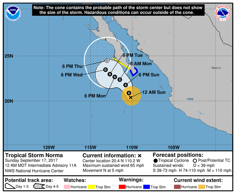
LOCATION...20.4N 110.2W
ABOUT 120 MI...200 KM NNE OF SOCORRO ISLAND
ABOUT 175 MI...280 KM S OF CABO SAN LUCAS MEXICO
MAXIMUM SUSTAINED WINDS...65 MPH...100 KM/H
PRESENT MOVEMENT...N OR 360 DEGREES AT 5 MPH...7 KM/H
MINIMUM CENTRAL PRESSURE...989 MB...29.21 INCHES
WATCHES AND WARNINGS
CHANGES WITH THIS ADVISORY:
None.
SUMMARY OF WATCHES AND WARNINGS IN EFFECT:
A Tropical Storm Warning is in effect for...
- Los Barriles to Todos Santos
A Tropical Storm Watch is in effect for...
- North of Todos Santos to Cabo San Lazaro
A Tropical Storm Warning means that tropical storm conditions are
expected somewhere within the warning area, in this case within 24
hours.
A Tropical Storm Watch means that tropical storm conditions are
possible within the watch area, in this case within 36 hours.
For storm information specific to your area, please monitor
products issued by your national meteorological service.
DISCUSSION AND 48-HOUR OUTLOOK
At 1200 AM MDT (0600 UTC), the center of Tropical Storm Norma was
located near latitude 20.4 North, longitude 110.2 West. Norma is
moving toward the north near 5 mph (7 km/h). The tropical storm is
forecast to turn toward the north-northwest this morning, followed
by a turn toward the northwest by Monday. On the forecast track,
the center of Norma will move near or just west of the southern Baja
California Peninsula today and Monday.
Maximum sustained winds are near 65 mph (100 km/h) with higher
gusts. Gradual weakening is expected for the next 48 hours.
Tropical-storm-force winds extend outward up to 90 miles (150 km)
from the center.
The estimated minimum central pressure is 989 mb (29.21 inches).
HAZARDS AFFECTING LAND
RAINFALL: Norma is expected to produce total rainfall accumulations
of 2 to 4 inches over the southern portion of the Mexican state of
Baja California Sur, with isolated maximum amounts up to 8 inches.
These rainfall amounts may produce life-threatening flash floods.
WIND: Tropical storm conditions are expected to first reach the
coast within the warning area by this afternoon. Tropical storm
conditions are possible within the watch area tonight or early
Monday.
SURF: Swells generated by Norma are affecting portions of the coast
of southwestern Mexico and Baja California Sur and will continue
into early next week. These swells are likely to cause life-
threatening surf and rip current conditions. Please consult
products from your local weather office.
NEXT ADVISORY
Next complete advisory at 300 AM MDT.
$$
Forecaster Zelinsky
NNNN

This post recieved an upvote from minnowpond. If you would like to recieve upvotes from minnowpond on all your posts, simply FOLLOW @minnowpond