Rak and Jebel Jais
Recently I was doing some geological field work with a team of people around Ras-al-Khaimaah, fondly called RAK in short. For those who haven't been this part of the world, it is bare and stunningly pretty in its own way. I didn't have much time to explore and see the sights, as we are mostly stuck to the rocks :) Still there were enough interesting shots I captured during this trip and been to some great places.
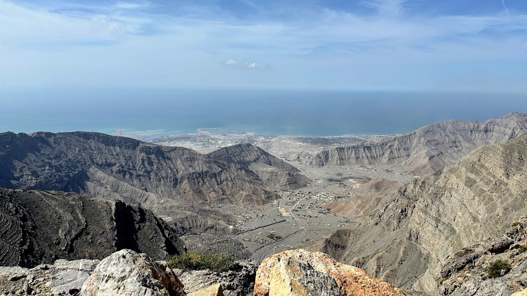
Above is the money shot at the top of Jebel Jais at the border between UAE and Oman. You can see the Persian gulf in the distance. However, what we were looking at mostly here is the the Jurassic rocks that we here standing, with Triassic below; are thrusted over the younger Cretaceous rocks seen in the distance near the coast line.
I rarely do this, but to explain that view view above, there is no option but to use a geological cross section and a map. So here it goes:
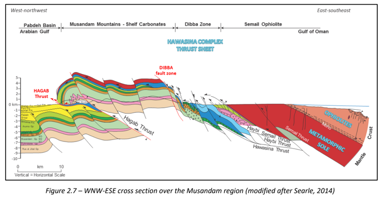
The first picture from the top of Jebel Jais is the approximate are of the geological section marked Hagab Thrust. What we did afterward is we drove down to the coast line, and looked sideway similar to this cross section. This is what we can see:
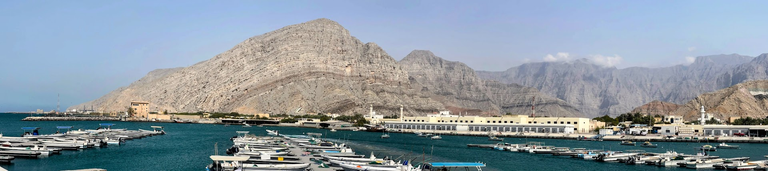
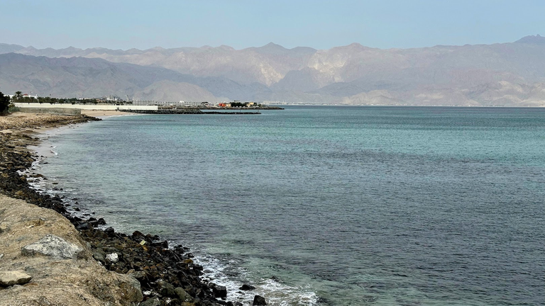
This is a panoramic view from Sha'am Fishing Boat Harbour, at the coastline, just north of the town of Sha'am. Jebel Jais, the first is at the top right most part of the skyline. Essentially we are looking at the frontal part of the steep forelimb of the hanging wall of the Hagab Thrust (see the geologic cross section), where Cretaceous carbonate rocks are are folded and dipping into the ocean. There you have it! Travel and Geology at the same time. This is how we roll!
Rugged beauty of RAK
So RAK is the northernmost of the seven emirates that makes UAE. For those who doesn't know this:
The United Arab Emirates (UAE), a federation located in the eastern part of the Arabian Peninsula, comprises seven distinct emirates. Each emirate maintains considerable autonomy, while also participating in federal structures
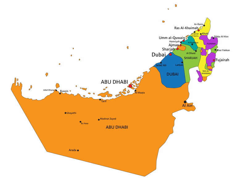
Hopefully this simple map helps you orient yourself. In fact I have seen tourist travelling there in RAK who are clueless on how many emirates there are and absolutely clueless on where they are in the world :) Modern day travel with GPS enables google maps and car services can do amazing things to your brain! You can be everywhere without much problem, but remain clueless about orientation the moment anyone takes the phone away from you. In fact the map above is not a simple map with numerous enclave and exclaves, it is rather difficult to orient yourself in northern UAE even with the knowledge of this map.
We went over that geologic cross section in 4 days.
- Semail Ophiolite
- Dibba
- Musandum Mountains
- Pabdeh Basin
Each day were dedicated to each of the geologic provinces. The type picture of the two of the provinces you have already seen. The Jebel Jais picture is in the Musandum Mountains, and the Sha'am coastal picture is perhaps a representative of the Pabdeh basin along the coast line. That said a lot of the aerial coverage is the Semail Ophiolite.
Ophiolite is a nothing buy a fragment of oceanic crust (and upper mantle) that is now thrusted up (due to a process called obduction, when two continent collides), and is exposed at the surface. Semail Ophiolite happened when Greater part of Iranian Plate collided with Arabian Plate and the Tethys Ocean was closed forming the present day Oman mountains.
Anyways it is hard to talk about this landscape without talking deep into Geology. Pardon me for this as I typical don't like to talk in jargon, and geology is all about that.
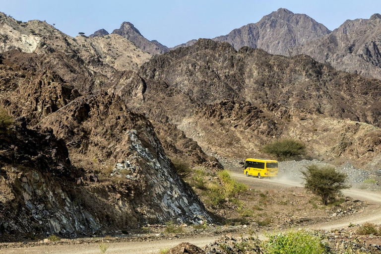
So one of the days, I think it was the first day, and we were deep into the Ophiolite terrain along a dirt road. There was a single ranch house at the end of this dirt road, kilometers from paved road and seems a million miles from civilization. It was late afternoon and we were looking at the rocks of the lunar landscape, in fact a landscape of rocks that belongs to the mantle, and this yellow school bus shows up! Can you believe this? This extremely modern looking looking school bus dropping kids to that single house at the end of the road! If that is not out of the place, I don't know what is!
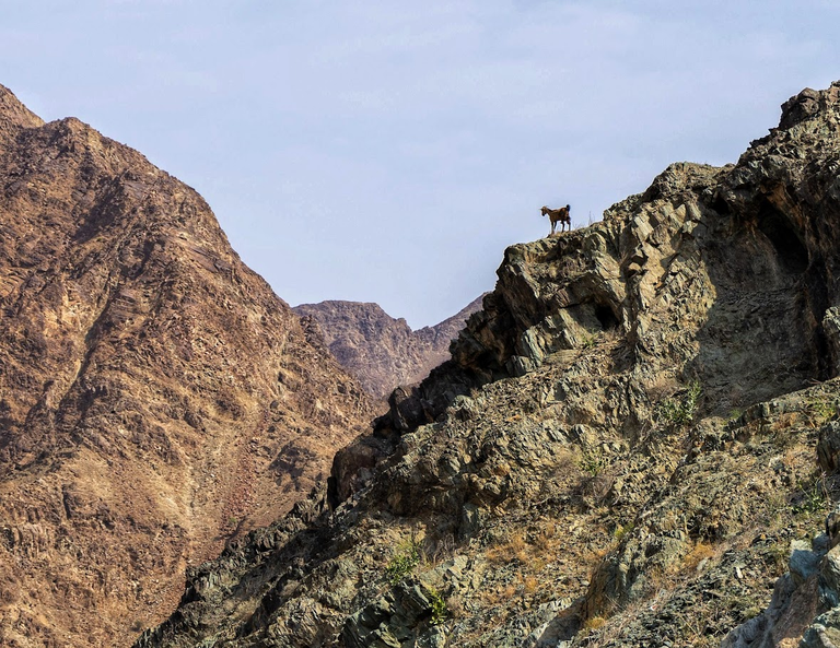
Then we have this goat standing in the mantle, quite literally! I know you guys are not getting the kick out of it probably, but I did!
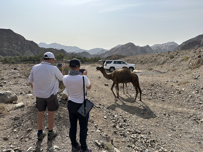
Got to show you camels. By the way, these are domestic, belongs to that ranch house you see, the low walls in the distance.
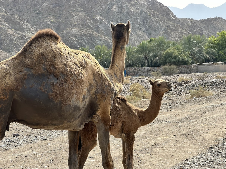
Yes, geologists go crazy and becomes instagram photographers when they see camels!
The landscape here is dry and rugged, here is the evidence. It rarely rains here.

But then you drive a few kilometers and you will end up by the Gulf of Oman!
There you have it. I hope you like it.


What a rugged, beautiful landscape! The goat and the camels look like they sprang from the landscape itself, but the school bus??....sticks out like a sore thumb. It really is odd that the bus travels all that way twice a day, but hey, the kids have to get to school.
I like places like this, it makes a person realise how small, fragile and inconsequential humanity is in comparison to the planet itself.
Exactly so. It is easy to imagine yourself the last person on Earth. Imagine how bright the stars!
This is made for you Galen. Lots and lots of dirt road and no roads and no people!
No people, good roads to "wheel" on with my truck? Seems like a very good match indeed!
I am positively surprised that the bus goes there. Here that is not the case. We have many rural kids drops out of school just because of transportation (among other things).
I have seen instances around the world where kids have to travel great distances and dangerous paths to go to school. They struggle to get to school while many kids in town try just as hard to avoid going lol.
Curious to know, what exactly is the objective of exploring these places ? Gulf of Oman is beautiful, looks like its being developed.
Very good question. I am surprised that no one asked this before.
I am a hydrocarbon (oil and gas) exploration geologist. Therefore, we work in subsurface. Problem is our ability to 'view' subsurface is limited. We can only use indirect methods for an broad coverage:
However, these are both limited in extent and uncertain in signal processing. To mitigate this uncertainty, we typically look at exposed rock at the surface in outcrop like the ones you see in the post as analog. So we study these rock in terms of their facies, and structural style, so that we can understand what is in subsurface with some degree of certainty before you drill a well.
Wow, quite the expertise.
Those mountain landscapes look almost surreal! Jurassic, Triassic and Cretaceous rocks in one place sounds cool :) I did take Geology in college in Kansas, but I would never be able to tell what those rocks are... You have a cool job.
Yes, I do have a cool job. I wouldn't have in any other way. Heading to Italy next week.
Wow so the school bus drives back the student on that single house. The rock formation is fascinating.
Yes. Seems like a single student as well.
I mean, goats and geology, what's not to love? This reminds me of the landscape in Morocco so much - it's like geology in action, right in front of you - the magnificent folds and thrusts of the earth. When areas like this aren't forested you have a whole different kind of beauty. Majestic, timeless, humbling. Loved this post. Thanks for taking the trouble to explain why the landscape looks as it does.
I agree, it does look similar.
Lots of carbonate in Morocco as well.
And thank you for the kind words. I do travel a lot for work, but mostly don't write about those trips and cetainly not the details. Here, I just couldn't!
It looks like a beautiful place. A couple of years ago my wife and I went down into an old copper mine and at one point the guy was talking about how the rock all around us was really really old, I don't remember now, like millions of years old maybe. I just reached out and touched the wall because it felt like a really special moment touch history like that.
Copper mine sounds cool. I should be able to tell if I know the location. We have a fairly good map of the entire US
It was the old Quincy mine up in Hancock, MI. They do tours and stuff. I think Michigan Tech even has classes down there in a classroom they built off one of the adits.
Beautiful photos. The place looks too arid despite being close to the sea.
Yes, there is very little rain in the Arabian peninsula despite being surrounded by water in three sides.
The landscape looks so rugged and dry. Pretty in it's own right for sure. Loved the goat!
Thanks. Dry indeed.
The Goat! Great pic actually!
We have a lot of folding layers here in Ecuador, too - the first time I came, I had just had a Geology-Crash-Course at University as part of my minor, "Spacial Science". Driving in the bus through the Andes and see all the things I had before just seen on paper and photos was so exciting! I forgot most of it by now, the only layers I currently work on are dough...
Thank you for the post!
Yes, so next time you come across a fold or fault or any interesting geology, grab a picture and post; and I might be able to comment intelligently on it.
Will do! I might have some pictures on an old hard drive, if that still works :-D I'll see if I can dig it up.
Ohh!!! interesting place, a bit dangerous but very nice to visit.
Now I wonder what that goat is doing 🐐 up there jjj 😄 OMG !
Spectacular pictures of camels 🐫 here in cuba 🇨🇺 in Varadero province, manage to see them and ride they are good @azircon 🤗.
Cheers bro, great experience and adventure. Happy day 😊🙏🏻!!!
No danger there. Perhaps one of the safest place in the world. Definitely better than my home town Houston, TX
Wow, stunning pictures! I must say you have an awesome profession AZ 🤩
I do have a exciting job. I have always enjoyed it.
Oh! You've been there 😮 I remember when me and my husband decided to go to Jebel Jais, he pinned the location but we didn't know what happened, I forgot what he used that time Waze or Google Maps, we lost in the rocky and rugged mountain of RAK and it was scary 😨 but thanks God we found our way back.
Yes, back roads are not well marked, but now it is much better in terms of phone signal.
True, no marking when you enter those rugged mountains. The site that we've reached has no signal it seems an isolated area.
You can check out this post and your own profile on the map. Be part of the Worldmappin Community and join our Discord Channel to get in touch with other travelers, ask questions or just be updated on our latest features.
Wow! They look like scenes in the movies. You have an exciting job out there.
thank you
Wow!
Interesting post!
Travel Digest #2491.
Become part of our travel community:
- Join our Discord
Hiya, @lauramica here, just swinging by to let you know that this post made it into our Honorable Mentions in Your post has been manually curated by the @worldmappin team. If you like what we're doing, please drop by to check out all the rest of today's great posts and consider supporting other authors like yourself and us so we can keep the project going!!PIZZA
Extraordinario lugar bastante calor debe hacer allí pero es hermoso
very informative and such great pictures. thank you for sharing azircon
That is a beautiful if not a bit parched landscape.
I love how a little knowledge allows one to understand how much time it would require for those formations to form.
It is stunning and of course the Camel and Goat are awesome :)
My dad will love this post so I am definitely sending him the Link!